The Aneto
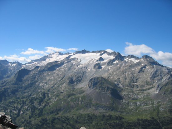
The peak of Aneto is the highest mountain in the Pyrenees and Aragon and, at 3,404 meters, the third highest in Spain. It is located in the Spanish province of Huesca, the northernmost of the three Aragonese provinces, 6 km south of the Franco-Spanish border. It forms the southernmost part of the Maladeta massif.
Aneto is located in the natural park of Poetas Maladeta, in the municipality of Benasque, in the province of Huesca, in Aragon, Spain. It is part of the Maladeta massif and is located in the Benasque River valley. It consists of Paleozoic granite reliefs and Mesozoic materials.
Mt. Aneto, the highest point of the Pyrenees and the second highest elevation of the Pyrenees, is the main climbing destination on the peninsula. To the north is the largest glacier in the Pyrenees, which is estimated to have lost more than half its area in the last 100 years. Aneto is our climbing goal for this summer, a very difficult paddock at Covid and our desire for the mountain, let’s be ambitious and this summer we will not pass, we will make this summit. We have already organized everything and together with our friends tiendaescalada.net are well equipped.
climbing plan
Location: Central Pyrenees, La Maladetta.
Altitude: 3,404 meters.
Uneven terrain: 1,550 meters.
Time: 5.15 hours.
Access: Benasque.
Starting point: Plan de la Besurta (1900).
Sanctuary: La Renclusa (2 140) BC.
Season: July-September.
Cartography: Alpine, Maladeta Aneto.
Terrain: rocky, stony and icy.
Level of difficulty: medium.
Effort: high.
Risk: high.
Equipment: glacier.
How to get there.
In Benasque, follow the C-139 along the upper Esera for 11 km, turn right which leads to the Hospital de Benasque hostel, and continue along Plan d’Estam to reach Plan de la Besurta (1900) (17 km from Benasque).
Itinerary of the journey
Follow the path that leads through the forest to the Rencluse Hut (2140). Then follow those steps that point the way to overcome the chaos of boulders that cover the area around Cresta de los Portillones. After Portillón Superior (2880), whose notch already frames the summit of Aneto, we descend to the glacier and walk diagonally under Cresta del Medio until we reach Collado de Coronas (3198).
Then we ascend a steep snowy slope that leads to the characteristic Mahoma Pass. It is a short and airy ridge that leads to the summit of Aneto (3404).
Other routes
As an alternative climbing route, you can descend from the Collado de Coronas directly to the glacier or on the eastern flank of the Cresta de los Portillones, descend to the Barranch Valley and return to the starting point along the Aiguallut trail.
If you want to avoid the overcrowding of the usual route, you can use the Coronas Valley trail. It starts at the open hut of Vallibirna (1950), is shorter and joins the previous one at Collado de Coronas. The approach is via Plan de Senarta, through 8 km of dirt road, open to traffic, but in very poor condition.
Observations Acclimatization is recommended for climbing Aneto, as the discomfort caused by altitude sickness leads to many abortions. It can be bypassed by climbing ahead of time from the same starting point on Tuc de Muller (3,010), which offers great views.